Make BestShareware.net your home page Add BestShareware.net to your favorites  

Homepage

Help Desk

Site Map

Popular

What's New

Featured
Search Software:
WWW         BestShareware.net
  MAC Software | Linux Software | Pocket PC | iPod Software | Zune Software
  Software Directories
Internet
Graphics
PC Tools
Applications
Development
DVD & Video
MP3 & Audio
Computer Games
Security & AntiVirus
  Applications
Business Finance
Personal Finance
Database Tools
Personal Managers
Business Managers
Inventory Management
Project Managers
Accounting Tools
Home & Education
Unit Conversion
Word Processing
Presentation Tools
Auction Tools
Spreadsheets

Geisom Professional

Geisom Professional 
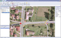
Geisom is a modular system designed for easy access to complex geographical information. Geisom has been designed for professionals who need to gain, download, analyze and present data in a three-dimensional relationship to the surface of the Earth.
Geisom Pro is an intuitive map and data editor which features comprehensible editing of data files (e.g. ESRI Shape, DGN, etc.) or even data sources located in the database. Geisom Pro may be used as an application installed on one computer or as a client-server solution, in which case the data source is located on a central server. Geisom Pro excels in its easy and intuitive user interface..


Software Information System Requirements
Version: 2.0
  • Microsoft Windows XP, Vista, 7, Server
  • Microsoft .NET Framework 2.0
License:Free to try, $429.47 to buy
File Size: 44.20 MB
Screenshot:View Screenshot
Rating :

Key Features of Geisom Professional:
  • Professional Dynamic map creation
  • Imaging of geometric objects by chosen attributes
  • Information gathering for projects
  • Unlimited number of layers
  • Supports vector formats: SHP (incl. DBF), DGN, DXF, DWG, DWF, DRW, NAP, CMX, PLT, PCT, SVG, WMF, E00, MIF etc.
  • Supports orthophotomap formats: JPG/JPW, TIF/TFW and MrSID
  • Unique picture data (orthophotomaps) optimizing
  • Ability to define perspectives for easy map orientation from data
  • Print manager to help with print jobs
  • Connection to Land Registry (Deeds) Office information
  • Traffic sign module, greenbelt passport, specified line types
  • Automatic program upgrades
  • Simple and intuitive user interface
  • State-of-the-art operating components, several colourful schemes
  • WMS/WFS layers
  • Transfers between coordinated systems
  • Free fourteen-day full trial version

  RELATED SOFTWARE DOWNLOADS FOR Geisom Professional
  • Global Mapper
    is more than just a viewer capable of displaying the most popular raster, elevation and vector datasets.


  • Mind2Chart
    allows to allocate resources, track project implementation, obtain and export reports.


  • Map Export
    is a GIS developer oriented tool for downloading and exporting background image.


  • CyD Image Mapper
    create image maps for your web site.


  • AgMapper For Windows Mobile
    AgMapper For Windows Mobile is GPS mapping software for Windows Mobile driven Pocket PC's.


  • MindMap Navigator for MindManager
    MindMap Navigator for MindManager simplifies visibility and navigation on big maps.


  • Touche Google Maps Extractor
    Touche Google Maps Extractor captures contact information such as business name, address.


  • Annapurna Region GPS Map
    Annapurna Region GPS Map is a Garmin-compatible digital maps.


  • VisiMap Professional
    VisiMap Professional is a hierarchical two-dimensional graphical representation.


  • AutoPlotter Professional
    AutoPlotter Professional is a complete survey and mapping software.


  • MindVisualizer Standard
    MindVisualizer is a productive mind mapping software that allows you to capture, visualize, manage and share idea/information.


  Submit Software | Privacy Policy | Terms of Use | Advertise with Us | Contact Us
 Copyright © BestShareware.net. All rights reserved.