Make BestShareware.net your home page Add BestShareware.net to your favorites  

Homepage

Help Desk

Site Map

Popular

What's New

Featured
Search Software:
WWW         BestShareware.net
  MAC Software | Linux Software | Pocket PC | iPod Software
  Software Directories
Internet
Graphics
PC Tools
Applications
Development
DVD & Video
MP3 & Audio
Computer Games
Security & AntiVirus
  Graphics
Graphic Converter
Icon Maker
Icon Tools
Screen Capture
Photo Editor
Screensaver Maker
Screensavers
SlideShow Maker
Animation Maker
Calendar Maker
Graphic Tools
Teacher Tools

Annapurna Region GPS Map

Annapurna Region GPS Map 
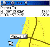
Annapurna Region GPS Map is the latest in an exciting new series of Garmin-compatible digital maps covering the major trekking and climbing regions of Nepal and the Himalaya.
TrekMapGPS products install on a PC for uploading to your GPS unit. The maps can be previewed in Garmin's MapSource (not included) or other compatible software for route planning or reviewing.
Upload to your GPS using MapSource or an upload utility such as SendMap20 by cGPSmapper. Plan your trip using Garmin's Trip & Waypoint Manager or other compatible software. Compatible GPS units include GPSmap, eTrex, Quest, Rino and zuno models.


Software Information System Requirements
Version:1.1.0
  • Windows 8/7/XP/Vista
  • 512 MB of RAM
File Size:516 KB
License:Free to try, $39.00 to buy
Screenshot:View Screenshot
Rating :

Key Features of Annapurna Region GPS Map:
  • Over 1200 searchable Points of Interest (POIs), including:
    • 716 towns and villages ("City" searchable)
    • 384 elevation spots
    • 12 passes
    • 44 summits
    • 91 glaciers and 41 lakes
    • airports and other places of interest
    • bridges and other man-made objects
    • over 60 miscellaneous labelled locations
    • 120+ accommodation areas and campsites
  • Contours at 100m / 500m / 1000m intervals
  • All major trekking routes, roads, tracks and paths
  • Rivers and streams
  • International and National Park borders

  RELATED SOFTWARE DOWNLOADS FOR ANNAPURNA REGION GPS MAP
  • AgMapper For Windows Mobile
    AgMapper For Windows Mobile is GPS mapping software for Windows Mobile driven Pocket PC's.


  • LandMap Vivo
    LandMap Vivo creates own true scaled Landmaps.


  • Touche Google Maps Extractor
    Touche Google Maps Extractor captures contact information such as business name, address.


  • GenealogMap
    easy to use genealogy software with flexible user interface, visual represent, publishing, and Web site creation features


  • GPSeasyCE
    easy to use map software for PocketPC & PocketPC 2002. It use raster maps which are eithe


  • EarthBrowser for Mac
    It is a three dimensional model of the earth with constantly updating live information.


  • Flash Map US States Silver
    with FLA source for web sites, interactive applications, presentations, and more.


  • Network Protocols Map Poster
    Network Protocols Map Poster - All network protocols illustrated on one Chart


  Submit Software | Privacy Policy | Terms of Use | Advertise with Us | Contact Us
 Copyright © BestShareware.net. All rights reserved.