|
AspMap
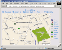
 AspMap is a high-performance, Web mapping component for embedding spatial
data access, display and analysis capabilities in ASP applications. AspMap
gives you the ability to generate map images, drill-down capability, thematic
mapping, point-to-point routing and other features that - generated on
the server - will make the map images fully interactive on the client-side.
AspMap can create images in any standard image file format, or even send
a bit-stream directly to the browser. Whether you have a local government
web site, a real estate web site or a vehicle tracking web site, or if
you provide location-based services, AspMap can give you the functionality
you need to turn the occasional visitor to your site into a regular user.
This installation pack includes a fully functional trial version of AspMap,
complete documentation, sample applications for Visual Studio, ASP.NET AJAX, and sample map data.
| Software Information |
System Requirements |
| Version: |
4.60 |
- Windows 7/NT4/2000/2003/XP/Vista
- Pentium II CPU
- 256 MB RAM
|
| License: | Free to try, $799.00 to buy |
| File Size: |
16.10 MB |
| Screenshot : |
View Screenshot |
| Rating : |  |
Here are some key features of "AspMap":
Mapping Features
- Multiple map layers.
- Dynamic map layers.
- Pan and zoom through map layers.
- Scale dependent layer display - each layer has a minimum and maximum display threshold.
Display only occurs when the current map's scale falls between the thresholds.
- Automated relates from map data to databases.
- Translucency support.
- Draw points, lines, ellipses, rectangles, polygons, labels and text strings directly onto maps.
Thematic Mapping
- Assign colors, symbols and shading to represent data values on the map.
- Thematic maps can be based on individual values, ranges or expressions.
Spatial and Attribute Searching
- Search for features along lines and inside boxes, areas, polygons and circles.
- Search within a specified distance of other features.
- Search for features using an expression.
- Query attribute data associated with selected features.
- Export selected features in Shapefile format.
A Variety of Labeling Options
- Cross-layer smart labeling - labels are positioned automatically to prevent overlapping between labels.
- Thematic labeling - enables control of label properties by using values in the customer's data.
For example font size and color could be adjusted to correspond to a state's population.
- Multi-line labels - allows text labels to appear on multiple lines instead of in one long string.
- Highway/interstate labeling - provides the ability to assign highway shield symbols for highways/interstates.
Routing
- Calculate routes between two points based on their coordinates.
- Calculate the quickest and shortest routes (based on distance or time).
- Generate turn-by-turn driving directions.
- Plot generated routes directly on the map.
On-The-Fly Projection
- Data from any projection can be combined into a common projection for viewing and analysis.
- Built-in support for 378 geographic and 2706 projected coordinate systems.
- Support for the OpenGIS WKT format for spatial reference systems.
Vector Data Sources
- Shapefiles (SHP).
- TAB files (TAB).
- Databases - AspMap enables you to plot locations using latitude/longitude coordinates retrieved from a database.
Raster Data Sources
Image Export Formats
Help and Support
- Detailed online documentation is included.
- Free upgrades and updates are provided for one full year from the date of purchase.
- Free technical support is given for one full year from the date of purchase.
RELATED SOFTWARE DOWNLOADS FOR ASPEASYZIP
- ODBC DAC Pro Edition
ODBC DAC (ODBC Data Access Components) is a component set for Delphi/C++Builder to access any database via ODBC interface directly
- ODBC DAC Standard Edition
component set for Delphi/C++Builder to access any database via ODBC interface directly
- Entity-Relationship Model Components
Allows to build visual ER diagram (read-only) from ODBC data source or from XML-file source.
- csDrawGraph
is an ASP component for creating graphs and charts, The resulting graph can be streamed to a browser or saved to a file.
- aspEasyZip
is an ASP component for use with the IIS Server from Microsoft,the main feature is that it can zip, unzip
- PolyMap DataBase Edition
PolyMap is a desktop mapping and geographic presentation software package for Windows to create thematic and informative maps for presentations
- Rich Chart Server for .NET
rich Chart Server generates captivating dynamic Flash charts from ASP.NET and Windows Forms applications available to .NET.
- SpreadsheetConverter to ASP & ASP.NET
generates a single ASPX page and an optional Code-Behind file for each Excel spreadsheet that it convert
- ASP.NET Dynamic Builder
Create User Interface for ASPX Page , Arrange Controls and Assign Standred Naming for each Control , Manage Bind and Load Data From Database to Page Controls Dynamiclly.
|
|


 AspMap is a high-performance, Web mapping component for embedding spatial
data access, display and analysis capabilities in ASP applications. AspMap
gives you the ability to generate map images, drill-down capability, thematic
mapping, point-to-point routing and other features that - generated on
the server - will make the map images fully interactive on the client-side.
 BestShareware.net. All rights reserved.


